COLLECTION NAME:
David Rumsey Historical Map Collection
Record
Author:
Drury, John G.
Date:
1945
Short Title:
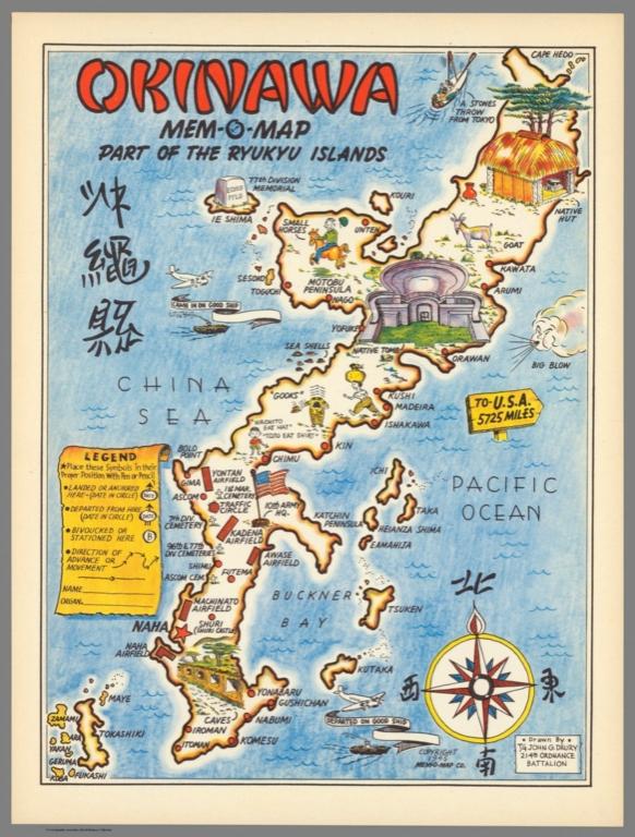
Okinawa Mem-O-Map part of the Ryukyu Islands
Publisher:
Mem-O-Map Co.
Publisher Location:
No, place of Pub.
Type:
Separate Map
Obj Height cm:
32
Obj Width cm:
24
Scale 1:
None shown
Note:
Colored pictorial map of Japan and Korea, in a series of Mem-o-Maps by John G. Drury of the 214th Ordnance Battalion US Government, produced for military personnel during the Second World War. Mem-O-Maps' purpose was as a souvenir map on which troops could keep trace of their ‘adventures’ and movements. The maps represent an important historical period and integrate pictorial and geographical elements in a unique way. The use of cartoons and familiar map shapes used to show the conditions and experiences that the troops must have faced in reality, also shows memorable spots, wildlife and banners "came in on good ship" and "departed on good ship". The legend encouraged service men to note where they “landed or anchored” and when, as well as where they “bivoucked or stationed” while there. Includes a decorative compass rose and the title in Japanese. Relief shown pictorially.
Country:
Japan
Country:
Korea
Subject:
Pictorial map
Subject:
Historical
Full Title:
Okinawa Mem-O-Map part of the Ryukyu Islands. Drawn by T/4 John G. Drury 214th_ Ordnance Battalion. Copyright 1945 Meme-O-Map Co.
List No:
11225.000
Publication Author:
Drury, John G.
Pub Date:
1945
Pub Title:
Okinawa Mem-O-Map part of the Ryukyu Islands. Drawn by T/4 John G. Drury 214th_ Ordnance Battalion. Copyright 1945 Meme-O-Map Co.
Pub Note:
See note field above.
Pub List No:
11225.000
Pub Type:
Separate Map
Pub Height cm:
32
Pub Width cm:
24
Image No:
11225000.jp2
Authors:
Drury, John G.
Link To Source
Okinawa Mem-O-Map part of the Ryukyu Islands