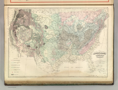
Detail View: David Rumsey Historical Map Collection: Geological Map of the United States and Territories.
|
Author:
|
Asher & Adams
|
|
Date:
|
1875
|
|
Short Title:
|
Geological Map of the United States and Territories.
|
|
Publisher:
|
Asher & Adams.
|
|
Publisher Location:
|
New York
|
|
Type:
|
Atlas Map
|
|
Obj Height cm:
|
42
|
|
Obj Width cm:
|
59
|
|
Scale 1:
|
7,900,000
|
|
Note:
|
Washington Meridian. Hand tinted full color. Shows railroads, settlements, counties, waterways, and lakes. Differentiates volcanic rocks and volcanic centers from the rocks of various periods. Relief shown with hachures. Engraved.
|
|
Reference:
|
P1300.
|
|
Country:
|
United States
|
|
Full Title:
|
Asher & Adams' Geological Map of the United States and Territories. Entered according to Act of Congress 1874 by Asher & Adams in the Office of the Librarian of Congress at Washington.
|
|
List No:
|
4977.080
|
|
Page No:
|
143-144
|
|
Series No:
|
85
|
|
Engraver or Printer:
|
Asher & Adams
|
|
Publication Author:
|
Asher & Adams
|
|
Pub Date:
|
1875
|
|
Pub Title:
|
Asher & Adams' New Columbian Rail Road Atlas and Pictorial Album of American Industry, Comprising a Series of New Copper Plate Maps Exhibiting the Thirty-Seven States ... Together With Illustrations and Descriptions of Mercantile and Manufacturing Establishments, Machinery, Works of Art, Mechanism, Trade-Marks, Etc., Etc. ... Compiled, Written, Drawn and Engraved Under the Supervision Of The Publishers, By Their Own Corps of Editors, Engineers, Topographers, and Artists.... New York: Asher & Adams, No. 59 Beekman Street. 1875
|
|
Pub Reference:
|
P1300.
|
|
Pub Note:
|
This is a very unusual and wonderful atlas - it combines the most complete Asher & Adams atlas map set (the same grouping as the late 1874 issue, but updated - see our #41) bound unfolded on edge (this is a huge book) with beautiful illustrations opposite each map of industrial establishments, products, and machinery. It has become very scarce. Its sheer size probably meant that the edition was small in number. Several of the maps are updated and copyrighted 1875; Colorado is substantially changed with the introduction of mountain ranges with "Gold, Silver, Copper and Lead Mineral Belt" overprinted on them. There may have been an 1883 issue of this atlas by George Adams, not listed in Phillips.
|
|
Pub List No:
|
4977.000
|
|
Pub Type:
|
Commercial Reference Book; National Atlas
|
|
Pub Maps:
|
60
|
|
Pub Height cm:
|
64
|
|
Pub Width cm:
|
45
|
|
Image No:
|
4977080
|
|
Download 1:
|
Full Image Download in MrSID Format
|
|
Download 2:
|
MrSID Image Viewer for Windows
|
|
Authors:
|
Asher & Adams
|
|
Collection:
|
Rumsey Collection
|